History
Gerry Feehan Receives the Legendary Invitation, A World Famous Newfoundland Tradition
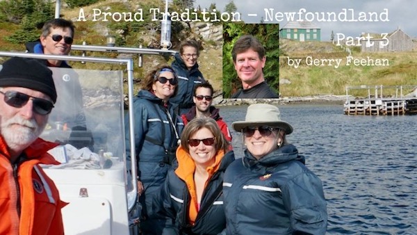
11By Gerry Feehan
This is the third of four parts in the Newfoundland series. Scroll down to find Part 1, Gros Morne, and part 2 North America’s Oldest European Settlement
If Newfoundlanders weren’t so damn friendly we’d have been on time for our Jiggs dinner.
Terra Nova National Park is situated in eastern Newfoundland, 399 sq km of rugged rock, trees and wetland, wrapped around idyllic fingers of Bonavista Bay. The Trans-Canada highway bisects the park, then continues southeast toward Come by Chance and eventually the capital, St. John’s, on the Avalon Peninsula. It was early October. Terra Nova was still open for business, but quiet, so we had our choice of primo campsites. As we checked in I grabbed a bag of firewood. It was going to be a cold night, with frost expected. The ranger stopped me, “No sense you paying for wood. The folks in site 17 just bought a big load. Just go over and join them when the fire starts.”
And so we did. And that’s how we met Burkey and Bev. Even before we reached their roaring fire, Burkey spotted us timidly approaching from the shadows, and without a word, pulled out spare chairs and began pouring drinks. It was Thursday before Thanksgiving. The Burkes were setting up camp, preparing for the arrival of friends and family, and prepping for the big occasion: Sunday’s Jiggs dinner. After a fun evening of chatter (interspersed with a few tunes from my ever-present ukulele) we rose to bid adieu. “You’ll come for dinner Sunday?” asked Barb. I did some quick calculating. We had a week left on The Rock but had yet to visit St. John’s. Plus there was the Irish Loop and Bonavista Peninsula to explore. And we had a long drive back west to Port Aux Basque, almost 1000km, in order to catch the ferry on Tuesday.
“Sure,” I said.

On Sunday we awoke to a gorgeous morning at the Cabot Highway RV Park, a few kilometers from the town of Trinity, on Bonavista Peninsula. (The intervening 3 days and our St John’s/Avalon/Irish Loop drive will be recounted in the fourth and final yarn of this series.) When we reached Trinity I headed straight through town, bound for the local pier, as I am wont to do. Preoccupied by the brightly painted clapboard homes, 19th century church spires and scenic fishing stages (houses hanging over the water used for cleaning cod), I failed to observe that the roadway was becoming dangerously narrow.

We ended up trapped on the town boat ramp, pointed seaward. There was no way to turn the motorhome around. Florence was starting in on my (justly-deserved) beratement when a boat pulled up to the wharf. “What are you after doing down there, b’y?” asked the operator with an amused look. With his guidance I was able to slowly reverse position and get the RV pointed away from the slippery slope and safely back toward land. I offered my thanks. “No trouble,” said he, bobbing in his boat. “I’m taking friends out for a tour of the bay this lovely morning. Would you and your wife like to join us?” I did some more calculating. It was a two-hour drive back to Terra Nova. Jiggs dinner was at 3pm. “We’d need to be back to shore by 1pm,” I said. “No worries,” he replied, “I’ll have you at the dock by noon at the latest.”
It was a fantastic outing. Skipper Bob and his partner Bonnie run www.trinityecotours.com. The tourist season was almost over and the day’s trip was just for fun. Although the usual fare is $90 a person, they refused to take our money. We followed the rugged coastline, where the remains of the ancient Appalachian Mountains slip into the sea. In Trinity Bay, while a whale spouted to starboard, we came alongside a fisherman hauling up net and cleaning cod. He offered us a bag overflowing with fillets and, with the waive of a hand, made it clear he wouldn’t accept payment.

Cod fishermen are a generous bunch

As we motored into a protected, hidden bay, the remains of a long-abandoned village came into view. Bonnie told us, “This place is known as Ireland’s Eye. On the other side of the island is a spot called Black Duck Cove. That’s where my dad lived until he was 11years old. In the mid 50’s the government began a resettlement program to get people who lived on remote islands to move to the mainland where there would be better access to services like hospitals and schools.”
In some respects it was forced relocation. Many people, rather than abandon their homes, floated their lodgings to the mainland communities. “The old place on Ireland’s Eye was left behind but my grandfather floated a house from Pope’s Harbour to New Bonaventure in August 1965. It was a saltbox style, with the porch and bathroom added later.”
Life was hard on The Rock 50 years ago.

Skipper Bob and the crew
Time flies when you’re playing on the ocean. It was after 2pm when Bob idled the boat back into the marina. We bid a hasty thank-you and adieu and raced for Terra Nova. When we arrived at the campground it was getting dark. All sites were vacant save one. Bev and Burkey were just breaking camp, headed back to Clarenville.
“We are so sorry,” I apologized. “No problem,” said Bev. “You said you were coming for scoff so I knew you’d be here. I did up a couple of plates. They’re still warm.”
A traditional Newfoundland Jiggs dinner consists of turkey, dressing, gravy, bread pudding, carrots, turnip, cabbage, mashed potatoes, pease pudding, figgy duff – and boiled salt beef. For dessert Barb likes to do blueberry crumble and partridgeberry cake topped with hot vanilla sauce. Simple really. And easy to whip up, especially from the cramped confines of your trailer, in a campground, in the cold. Each platter held enough food for three Jiggs dinners. Burkey laughed and told us that a Newfoundlander’s idea of fine dining is a full plate. I offered him two fresh cod fillets and, although it was a little like carrying coals to Newcastle, he graciously accepted.
Florence and I were the only campers in Terra Nova that night. As they drove away Burkey said, “No sense you buying firewood, there’s plenty left.” Bev waived goodbye and they rolled out of our lives.
I looked at the overflowing feast, loosed my belt and dug in.

Jiggs Dinner
Next time: St John’s and the Irish Loop
Gerry Feehan is an award-winning travel writer and photographer. He lives in Kimberley, BC.
 Gerry Feehan is an award-winning travel writer and photographer. He and his wife Florence live in Kimberley, BC!
Thanks to Kennedy Wealth Management for sponsoring this series. Click on the ads and learn more about this long-term local business.
Gerry Feehan takes us to North America’s Oldest European Settlement
Click to read more travel stories.
February 14, 2025 – Alberta, Canada – A compelling new documentary, Cooking with Hot Stones: 200th Anniversary of Fort Assiniboine, is set to air on Wild TV, RFD TV Canada, Cowboy Channel Canada, and you can click here to stream for FREE on Wild TV’s streaming service, Wild TV+. This engaging one-hour feature will take viewers on a journey through time, exploring Fort Assiniboine’s rich history from 1823 to 2023.
Fort Assiniboine is a significant landmark in Alberta, playing a crucial role in Indigenous history, the fur trade, and the western expansion of Canada. This documentary captures the spirit of the region, illustrating how it has evolved over two centuries and how it continues to shape the cultural fabric of the province today.
Wild TV will make the documentary free to stream on Wild TV+ (insert link here once push it over to app) on February 14th so that it can be easily accessed in classrooms and other educational settings throughout the region, ensuring the historical significance of Fort Assiniboine reaches a wider audience.
Produced by Western Directives Inc., Cooking with Hot Stones: 200th Anniversary of Fort Assiniboine brings historical moments to life with vivid storytelling, expert interviews, and breathtaking cinematography.
“We are very excited to partner with Wild TV as part of our one hour documentary production. Based in Alberta, we respect the hard work and quality programming that Wild TV brings to a national audience. With the broadcast opportunity, Wild TV gives our production the ability to entertain and educate Canadians across the country on multiple platforms,” said Tim McKort, Producer at Western Directives.
Scott Stirling, Vice President of Wild TV, also expressed enthusiasm for the project: “At Wild TV, we are passionate about telling Canadian stories that resonate with our audiences. This documentary not only highlights a crucial piece of our nation’s history but also celebrates the resilience and contributions of Indigenous peoples, traders, and settlers who shaped the land we call home today. We are proud to bring Cooking with Hot Stones: 200th Anniversary of Fort Assiniboine to our viewers across Canada.”
Airtimes for Wild TV can be found here.
For airtimes on RFD TV Canada, click here.
For airtimes on Cowboy Channel Canada, visit CCC’s schedule.
Frontier Centre for Public Policy
Hungarian Revolution of 1956: A Valiant Effort to Overthrow Communist Rule
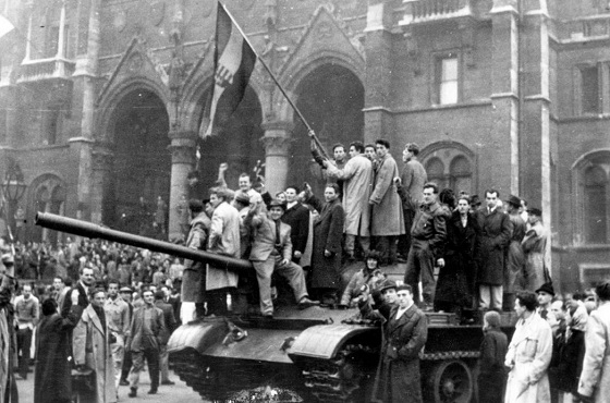
Civilians wave Hungary’s national flag from a captured Soviet tank in Budapest’s main square during the anti-communist uprising of October 1956. AP Photo
From the Frontier Centre for Public Policy
By Gerry Bowler
For a time, Moscow seemed willing to accept change in Hungary, but when Nagy announced that his country would leave the Warsaw Pact and become neutral in the Cold War, that was a bridge too far for Khrushchev.
After World War II ended in the summer of 1945, the Soviet Red Army found itself to be in possession of Eastern Europe. In the next few years, the USSR extinguished the young democracies in Poland, Czechoslovakia, Romania, Latvia, Lithuania, and Estonia, while imposing Stalinist governments on autocracies such as Bulgaria and Hungary. With Marxist regimes taking over in eastern Germany, and Albania and Yugoslavia as well, Winston Churchill spoke truly when he said that “from Stettin the Baltic to Trieste in the Adriatic, an iron curtain has descended across the continent.”
In many of these countries, there was considerable resentment over the Russian occupation. In the Baltic republics, Romania, Croatia, Belarus, Poland, and Ukraine, doomed anti-Soviet guerilla movements with names like the “Forest Brothers,” the “Cursed Soldiers,” or “Crusaders,” fought underground wars that\ lasted for years. In June 1953 in East Berlin, workers rose up in protests against their communist masters, sparking a short-lived rebellion that spread to hundreds of towns before being crushed by Russian tanks. The most serious of these insurrections was the Hungarian Revolution of 1956. By 1956, there were stirrings of discontent in the Hungarian People’s Republic. Under the state control of industry, forced agricultural collectivization, and the shipping of produce to the Soviet Union, the economy was in bad shape. The supply of consumer goods was low and standards of living were dropping. Secret police surveillance of the population was harsh, while many Hungarians resented the suppression of religion and the mandatory instruction of the Russian language in schools. As news leaked out about Soviet Premier Nikita Khrushchev’s denunciation of Stalin in the so-called “Secret Speech,” hopes grew that reform of the communist system was possible.
Marxist intellectuals began to form study circles to discuss a new path for Hungarian socialism, but their cautious proposals were suddenly overtaken by demands for change by young people. On Oct. 22, 1956, students at the Technical University of Budapest drew up a list of demands for change known as the “Sixteen Points.” They included free elections, a withdrawal of Soviet troops, free speech, and an improvement in economic conditions.
On the afternoon of the next day, these points were read out to a crowd of 20,000 who had gathered at the statue of a leader of the Hungarian rebellion of 1848. By 6 p.m., when the students marched on the Parliament Building, the crowd had grown to around 200,000 people. This alarmed the government, and later that evening Communist Party leader Erno Gero took to the radio to condemn the Sixteen Points. In reaction, mobs tore down an enormous statue of Stalin.

People surround the decapitated head of a huge statue of Josef Stalin in Budapest during the Hungarian Revolution in 1956. Daniel Sego (second L), who cut off the head, is spitting on the statue. Hulton Archive/Getty Images
On the night of Oct. 23, crowds gathered outside the state broadcaster, Radio Budapest, to demand that the Sixteen Points be sent out over the air. The secret police fired on the protesters, killing a number of them. This enraged the demonstrators who set fire to police cars and seized arms from military depots. Army units ordered to support the secret police rebelled and joined the protest. The government floundered; on the one hand, they called Soviet tanks into Budapest; on the other hand, they appointed Imre Nagy, seen as a popular reformer, as prime minister.
As barricades were being erected by protesters and shots were being exchanged with secret police units, Nagy was negotiating with the Soviets who agreed that they would withdraw their tanks from the capital. Over the next few days, the rebellion spread; factories were seized, Communist Party newspapers and headquarters were attacked, and known communists and secret police agents were murdered. The new prime minister released political prisoners and promised the establishment of democracy, with freedom of speech and religion.
For a time, Moscow seemed willing to accept change in Hungary, but when Nagy announced that his country would leave the Warsaw Pact and become neutral in the Cold War, that was a bridge too far for Khrushchev. Fearing the collapse of the entire Soviet bloc, he made plans for an invasion of Hungary. By Nov. 3, the Red Army had surrounded Budapest, and the next day heavy fighting erupted as armoured columns entered the city. Some units of the Hungarian army fought back, joined by thousands of civilians, but the end was predictable. After a week of battles, with over 20,000 dead and wounded, resistance crumbled. A new Soviet-approved government under János Kádár purged the army and Communist Party, arrested thousands, and executed rebel leaders including Nagy.
Hundreds of thousands of refugees fled, many of them settling in Canada and the United States. World condemnation of the USSR was strong; critics of the Soviets included many communists in the West who resigned their party membership. Not until the collapse of the Soviet hold on Eastern Europe in 1989 did Hungarians get another taste of freedom.
Published in the Epoch Times.
Gerry Bowler, historian, is a Senior Fellow at the Frontier Centre for Public Policy.

NATO commits to 5% defense floor after Trump pushes allies to step up
It’s not enough to just make military commitments—we must also execute them

Ottawa Funded the China Ferry Deal—Then Pretended to Oppose It

Red Deer Hospital Lottery 2025 Winners

Municipal government per-person spending in Canada hit near record levels

The Oil Price Spike That Didn’t Happen

Repeal the EV mandate, Mr. Carney
-
 Crime2 days ago
National Health Care Fraud Takedown Results in 324 Defendants Charged in Connection with Over $14.6 Billion in Alleged Fraud
-
 Health2 days ago
RFK Jr. Unloads Disturbing Vaccine Secrets on Tucker—And Surprises Everyone on Trump
-
 Business1 day ago
Elon Musk slams Trump’s ‘Big Beautiful Bill,’ calls for new political party
-
 International23 hours ago
CBS settles with Trump over doctored 60 Minutes Harris interview
-
 Business15 hours ago
Latest shakedown attempt by Canada Post underscores need for privatization
-
 Business15 hours ago
Why it’s time to repeal the oil tanker ban on B.C.’s north coast
-
 Censorship Industrial Complex1 day ago
Global media alliance colluded with foreign nations to crush free speech in America: House report
-
 International1 day ago
RFK Jr. tells Tucker how Big Pharma uses ‘perverse incentives’ to get vaccines approved