weather
Mozambique mourns as Cyclone Idai’s toll rises above 300

CHIPINGE, Zimbabwe — Mozambique on Wednesday began three days of national mourning for more than 200 victims of Cyclone Idai, one of the most destructive storms southern Africa has experienced in decades. In
The full extent of the devastation will only be known once floodwaters from torrential rains, expected to continue into Thursday, recede. It will be days before Mozambique’s inundated plains drain toward the Indian Ocean, and aid groups have warned the waters are still rising.
People have been reported clinging to rooftops and trees since the cyclone roared in over the weekend. The United Nations humanitarian office said the town of Buzi, with some 200,000 people, was at risk of becoming at least partially submerged.
“Flood waters are predicted to rise significantly in the coming days and 350,000 people are at risk,” the U.N. office said.
Zimbabwean President Emmerson Mnangagwa received a
Some bodies from Zimbabwe have been swept down the mountainside into Mozambique. “Some of the peasants in Mozambique were calling some of our people to say, ‘We see bodies, we believe those bodies are coming from Zimbabwe,'” said July Moyo, the minister of local government.
Mozambique’s president late Tuesday said more than 200 people were confirmed dead there. President Filipe Nyusi after flying over the affected region on Monday said he expected more than 1,000 deaths.
Aid workers were shocked as they arrived in the badly hit Mozambique port city of Beira, estimated to be 90
“The power of the cyclone is visible everywhere with shipping containers moved like little Lego blocks,” the aid group CARE’s Mozambique country director Marc Nosbach said.
International aid has started trickling in to ease the crisis, while churches in Zimbabwe collected supplies to send on.
“Everyone is doubling, tripling, quadrupling whatever they were planning” in terms of aid, said Caroline Haga of the Red Cross in Beira. “It’s much larger than anyone could ever anticipate.”
On Wednesday, the Emirates News Agency cited the Emirates Red Crescent as saying that the United Arab Emirates would provide 18.3 million dirhams ($4.9 million) to Mozambique, Zimbabwe and Malawi. Zimbabwe’s president said a planeload of aid from the UAE was expected to arrive in the capital, Harare, later Wednesday.
The chairman of the African Union Commission said the continental body would provide $350,000 in immediate support to the countries.
The European Union has released 3.5 million euros ($3.9 million) in emergency aid, and the United Kingdom pledged up to 6 million pounds ($7.9 million). Tanzania’s military has airlifted 238 tons of food and medicine, and three Indian naval ships have been diverted to Beira to help with evacuations of stranded people and other efforts.
Sacha Myers of the
Now hunger and illness are growing concerns. Crops across the region have been destroyed. Waterborne diseases are likely to spread.
“There are large areas where people are really finding it difficult to find sources of clean water,” Gert Verdonck, the emergency
___
Associated Press writers Andrew Meldrum and Cara Anna in Johannesburg and Matt Sedensky in New York contributed.
___
Follow Africa news at https://twitter.com/AP_Africa
Farai Mutsaka, The Associated Press
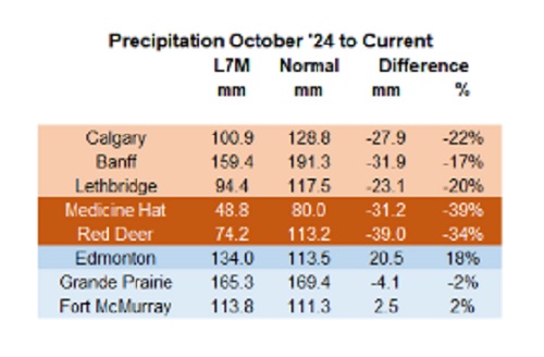

Below are my updated charts through April 2025 along with the cumulative data starting in October 2024. As you can see, central and southern Alberta are trending quite dry, while the north appears to be faring much better. However, even there, the devil is in the details. For instance, in Grande Prairie the overall precipitation level appears to be “normal”, yet in April it was bone dry and talking with someone who was recently there, they described it as a dust bowl. In short, some rainfall would be helpful. These next 3 months are fairly critical.
 |
Thanks for reading William’s Substack!
Subscribe for free to receive new posts and support my work.
From the Daily Caller News Foundation
![]()
By Hailey Gomez
Hurricane Milton officially made landfall near Siesta Key, Florida, on Wednesday night as local residents have either bunkered down or fled from the areas expected to be hit, according to the National Hurricane Center.
Dropping from a Category 4 to Category 3 storm right before landfall, the devastating storm had 120 mph sustained winds and higher gusts, the National Hurricane Center reported. Warnings about Hurricane Milton began early in the week, with lawmakers and officials urging residents within Florida’s Gulf Coast area to flee from their homes or be prepared for disastrous impacts, according to The Associated Press News.
“As Hurricane Milton makes landfall near Sarasota county, now is the time to shelter in place. First responders are staged and ready to go, as soon as weather conditions allow. Search and rescue efforts will be well underway to save lives before dawn, and they will continue for as long as it takes,” Republican Florida Gov. Ron DeSantis posted to X.
An estimated 2 million people, including those within the Tampa, St. Petersburg and Clearwater, Florida, area, were under a flash-flood warning from the Tampa National Weather Service, as “between 6 and 12 inches of rain” had already fallen.
Violent videos of the storm have began to circulating on X showing powerful winds tearing apart homes, trees and power lines.
BREAKING: Multiple people dead following tornado outbreak from Hurricane Milton in St. Lucie County, Florida, local media reports#HurricanMilton #miltonhurricane #Milton #StormFootage #FloridaStorm https://t.co/EoMxODqfuV pic.twitter.com/UrMEsXE22j
— Smriti Sharma (@SmritiSharma_) October 10, 2024
Early reports indicated fatalities occurred due to tornado touchdowns prior to landfall on Florida’s Atlantic coast, according to West Palm Beach-based affiliate WPTV. While details remain unclear about the deceased, St. Lucie County Sheriff Keith Pearson confirmed to the outlet “multiple people” have been killed.
The storm comes on the heels of Hurricane Helene, a Category 4 storm, which resulted in the deaths of over 200 people as it ripped through North Carolina, Georgia, South Carolina, Tennessee and Virginia after first making landfall in Florida on the evening of Sept. 26.

RFK Jr. says Hep B vaccine is linked to 1,135% higher autism rate

Blind to the Left: Canada’s Counter-Extremism Failure Leaves Neo-Marxist and Islamist Threats Unchecked

Why it’s time to repeal the oil tanker ban on B.C.’s north coast

Alberta Provincial Police – New chief of Independent Agency Police Service
-
 Energy1 day ago
B.C. Residents File Competition Bureau Complaint Against David Suzuki Foundation for Use of False Imagery in Anti-Energy Campaigns
-
 COVID-191 day ago
Court compels RCMP and TD Bank to hand over records related to freezing of peaceful protestor’s bank accounts
-
 Alberta2 days ago
Alberta uncorks new rules for liquor and cannabis
-
 Crime2 days ago
Project Sleeping Giant: Inside the Chinese Mercantile Machine Linking Beijing’s Underground Banks and the Sinaloa Cartel
-
 C2C Journal24 hours ago
Canada Desperately Needs a Baby Bump
-
 International1 day ago
Trump transportation secretary tells governors to remove ‘rainbow crosswalks’
-
 Alberta1 day ago
Alberta Next: Alberta Pension Plan
-
 Agriculture11 hours ago
Lacombe meat processor scores $1.2 million dollar provincial tax credit to help expansion