weather
January was officially Australia’s hottest month on record

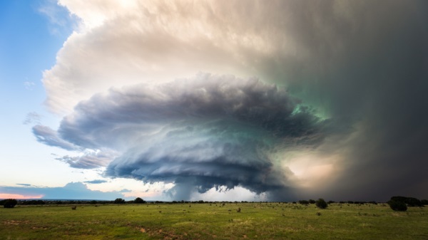
CANBERRA, Australia — Australia sweltered through its hottest month on record in January and the summer of extremes continued with wildfires razing the drought-parched south and flooding in expanses of the tropical north.
Australia’s Bureau of Meteorology confirmed the January record on Friday as parts of the northern hemisphere had record cold.
Australia’s scorching start to 2019 — in which the mean temperature across the country for the first time exceeded 30 degrees Celsius (86 degrees Fahrenheit) — followed Australia’s third-hottest year on record. Only 2005 and 2013 were warmer than 2018, which ended with the hottest December on record.
Heat-stressed bats dropped dead from trees by the thousands in Victoria state and bitumen roads melted in New South Wales during heatwaves last month.
New South Wales officials say drought-breaking rains are needed to improve the water quality in a stretch of a major river system where hundreds of thousands of fish died in two mass deaths during January linked to excessive heat. A South Australia state government report on Thursday found that too much water had been drained from the river system for farming under a management plan that did not take into account the impact of climate change on the river’s health.
The South Australian capital Adelaide on Jan. 24 recorded the hottest day ever for a major Australian city — a searing 46.6 C (115.9 F).
On the same day, the South Australian town of Port Augusta, population 15,000, recorded 49.5 C (121.1 F) — the highest maximum anywhere in Australia last month.
Bureau senior climatologist Andrew Watkins described January’s heat as unprecedented.
“We saw heatwave conditions affect large parts of the country through most of the month, with records broken for both duration and also individual daily extremes,” Watkins said in a statement.
The main contributor to the heat was a persistent high-pressure system over the Tasman Sea between Australia and New Zealand that blocked cold fronts from reaching southern Australia.

Rainfall was below-average for most of the country, but the monsoonal trough has brought flooding rains to northern Queensland state in the past week, leading to a disaster declaration around the city of Townsville.
Queensland’s flooded Daintree River reached a 118-year high this week.
Emergency services reported rescuing 28 people from floodwaters in the past week.
“The vast bulk of the population will not have experienced this type of event in their lifetime,” State Disaster Coordinator Bob Gee told reporters, referring to the extraordinary flooding.
Townsville Mayor Jenny Hill described the torrential rain as a “one-in-100-year event” that had forced authorities to release water from the city dam. The water release would worsen flooding in low-lying suburbs, but would prevent the Ross River from breaking its banks.
In the southern island state of Tasmania, authorities are hoping rain will douse more than 40 fires that have razed more than 187,000 hectares (720 square miles) of forest and farmland by Friday. Dozens of houses have been destroyed by fires and flooding in recent weeks.
Milder weather since Thursday has lowered the fire danger but it was forecast to escalate again from Sunday.
The Climate Council, an Australian independent organization formed to provide authoritative climate change information to the public, said the January heat record showed the government needed to curb Australia’s greenhouse gas emissions which have increased during each of the past four years.
“Climate change is cranking up the intensity of extreme heat, and January’s record-breaking month is part of a sharp, long-term upswing in temperatures driven primarily from the burning of fossil fuels,” the council’s acting chief executive Martin Rice said in a statement.
Rod McGuirk, The Associated Press
Heartland Daily News
On Extreme Weather, the More We Learn, the More We Know How Little We Knew Before (and Still Don’t Know)
Fr0m Heartland Daily News
No EF5 tornado, “one of the most catastrophic weather events on Earth … [which can] grow to be more than a mile wide and pack winds over 200 mph—stronger than any Category 5 hurricane on record across the Atlantic basin,” has struck the United States in more than 11 years—the longest such EF5 drought since consistent records have been maintained.
In contrast to many climate scientists and writers with the mainstream media covering climate change, who in their hubris claim the science is settled, Albert Einstein expressed modesty with regard to his knowledge, reportedly saying, “The more I learn, the more I realize how much I don’t know.”
Eistein, a genius by any measure, was not the first to express such wisdom. Socrates, nearly 2,400 years ago, reputedly stated, “The only true wisdom is in knowing you know nothing,” and Aristotle expressed a similar sentiment, saying, “The only true wisdom is in knowing you know nothing.” Would that contemporary climate researchers displayed such a cautious, honest assessment of the state of knowledge in their field about the causes and consequences of contemporary climate change—but they rarely do.
Still, research comes out daily suggesting that far more remains unknown about climate change and the extent to which it drives extreme weather than is known by climate scientists and their journalist sycophants, and is assumed, and built into, climate models. Two recent studies provide examples showing this.
One recent study, published in the peer-reviewed journal Geophysical Research Letters, examines the correlations of tropical cyclone (TC) activity in the Atlantic and Pacific hurricane basins to multi-decadal variations in sea-surface temperatures tied to shifts in Atlantic Multidecadal Variability (AMV). In analyzing two sets of climate model simulations, adding and subtracting AMV anomalies, researchers found the Atlantic and Pacific respond differently to warm AMV phases, which produce warmer temperatures:
Relative to cold or negative AMV anomalies, a warm AMV:
produces much more frequent TCs (including those making landfalls) over the North Atlantic. This is because AMV+ offers favorable conditions for TC development, including warmer SSTs, higher relative humidity, increased relative vorticity, and weaker vertical wind shear. By contrast, AMV+ causes less frequent TCs across the western North Pacific and South Pacific due to unfavorable conditions for TC occurrence (stronger vertical wind shear and less moist air). The contrasts in TC environment are due to increased zonal flow between the Atlantic and Pacific basins with AMV+.
What they didn’t find to be a factor in hurricane strength or formation was long-term global climate change. Rather, climate models suggest shifts in the Atlantic Ocean current oscillations are the forcing factor for tropical cyclones, or their absence. This study lends credence to the Intergovernmental Panel on Climate Change’s (IPCC) most recent AR6 physical science report, which confirms that there is no detection or attribution of any trend for either the number or strength of tropical cyclones tied to climate change. The IPCC’s assessment suggested that even under the most extreme emission scenarios, it could find no evidence climate change had or would affect tropical cyclones through 2100. (See chart below.)

Despite the IPCC’s clear statements and the findings in this new research, I’d bet money that this year when tropical storms and hurricanes form, especially when one or the other makes landfall and causes damage, mainstream media outlets will publish stories claiming climate change is to blame, citing “studies” from bogus climate science outfits like World Weather Attribution as evidence supporting their claim.
And, of course, hurricanes are only one type of extreme weather event we are only beginning to understand, and, as a result, show how little we know about their formation and cause. Tornados are another such type of event.
Every year, some scientists and reporters in the mainstream media try to tie climate change to the frequency or strength of tornados. Climate Realism has debunked such claims on dozens of occasions, citing research demonstrating there is no trend in increasing numbers or strength of hurricanes. Now the UPI is reporting the same fact.
One recent article published by UPI noted that no EF5 tornado, “one of the most catastrophic weather events on Earth … [which can] grow to be more than a mile wide and pack winds over 200 mph—stronger than any Category 5 hurricane on record across the Atlantic basin,” has struck the United States in more than 11 years—the longest such EF5 drought since consistent records have been maintained. And this is despite billions of additional tons of carbon dioxide being emitted into the atmosphere over that 13-year period. Commenting on this blessed severe tornado drought, UPI writes:
On May 20, 2013, an extremely powerful tornado destroyed a huge part of Moore, Okla. Eleven years later, it remains the most recent tornado to be rated EF5, the strongest possible rating on the Enhanced Fujita Scale. The 11-year gap is the longest since official U.S. records began in 1950.

Before the Moore tornado, the blockbuster tornado season in 2011 led to the confirmation of five EF5 twisters, including the Joplin, Missouri, EF5 that killed 161 people. A total of 50 tornadoes have been rated F5/EF5 since records began in the United States in 1950.
Meteorologist Bob Henson said in 2023 that the current EF5 “drought” is hard to explain since damage estimates can be subjective. Damage to a “well-constructed building” is the most common factor that helps the National Weather Service (NWS) confirm an EF5, yet many homes in the U.S. do not meet that criteria.
During this busy tornado season, think back to how many stories you’ve already seen that mentioned climate change as a factor—modifying their timing, number, behavior, and power. Then, remember mainstream media column inches and broadcast air-time to the contrary, there is no evidence whatsoever that climate change has, will, or can, even in climate models, impact tornados.
Heartland Institute Research Fellow Linnea Lueken answers the question: “Is climate change making tropical cyclones, meaning hurricanes and tropical storms, worse around the world?” The answer is, “No.”
Agricultural Moisture Situation Update – January 3, 2024
Synopsis
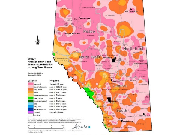
This year’s El Niño has developed into a strong El Niño and currently has a 54% chance of developing into a “historically strong” event, according to NOAA. Current forecasts are projecting El Niño to diminish in April 2024. In the past for Alberta, not all El Niño’s have resulted in warmer and drier weather; however, this unusually warm and dry winter will forever be tied to the 2023-2024 El Niño and will serve as an important data point in the future.
In the 90-days since October 6, 2023, temperatures have remained well above average, with many parts of the northern-half of the province seeing temperatures this warm less than once in 50 years (Map 1). This coupled with low precipitation accumulations has resulted in virtually snow free
conditions across parts of all four of our agricultural regions
(Map 2).
Winter Precipitation Accumulations
November 1, 2023 to January 3, 2024
Since November 1st, the unofficial start to winter in Alberta, precipitation has been well below average across much of Alberta’s agricultural areas (Map 3).

Most of the lands south of Grande Prairie and north of Ponoka are estimated to have a winter thus far, this dry on average, less than once in 50-years. Dry conditions have also persisted across the Central and Southern Regions, ranging from a few widely scattered pockets of near normal to at least once in 25 year lows, centered around the Jenner area (approx. 200 km east of Calgary). Total accumulations currently range from less than 3 mm through parts of the North West and North East Regions up to only 20-30 mm along the foothills and through the western and northern portions of the Peace Region (Map 4).


For the dryer parts of the North West and North East Regions this translates to less than 10% of the 1991-2020 average (Map 5).

Elsewhere, most other lands have received precipitation accumulations that have generally been less
than 50% of the 1991-2020 average.
Perspective
From an annual moisture budget perspective, October through to March generally mark the dry season across the agricultural areas (Map 6), accounting for only about 20% of average annual accumulations across most of the Southern Region, to upwards of 30-35% across the Peace Region.

These significant moisture deficits thus far (50% of the way through the dry season), while discouraging to many, make up only a small portion of the annual moisture budget for an area. Winter is not over yet and if the current forecast is correct, a significant cold snap is on its way over the next few days and it is expected to persist well into next week, perhaps even longer. Along with the cold snap, there is also a forecast for moisture and the promise of at least some snow cover across many areas.
Spring is yet many weeks away and anything can happen between now and then. Furthermore, February on average, is the driest month of the year with most agricultural lands normally receiving less than 15 mm of moisture during this month (Map 6). Let’s hope, for the sake of our producers,
that we descend into at least near “normal” winter conditions and that we see one of Alberta’s famous weather reversals, with respect to moisture. Above average snow fall is very much needed now. Much of the land is extremely dry and has been held tenaciously in the grip of a long-lasting dry
cycle that needs to end soon!


Secret Service Director Kimberly Cheatle resigns after major backlash over Trump assassination attempt

Scotia Place – Calgary unveils design for new arena / events centre
Liberals offer no response as Conservative MP calls Trudeau a ‘liar’ for an hour straight

Employee wins lawsuit filed by gov’t agency after losing job for refusing COVID shot
-
National1 day ago
Liberals offer no response as Conservative MP calls Trudeau a ‘liar’ for an hour straight
-
 COVID-191 day ago
Leaked documents: German gov’t lied about shots preventing COVID, knew lockdowns did more harm than good
-
 Economy1 day ago
Kamala Harris’ Energy Policy Catalog Is Full Of Whoppers
-
 International1 day ago
Switzerland’s new portable suicide ‘pod’ set to claim its first life ‘soon’
-
 Business1 day ago
Federal government seems committed to killing investment in Canada
-
 International20 hours ago
House Passes Bipartisan Resolution Establishing Trump Assassination Attempt Task Force
-
 Crime10 hours ago
Everything you need to know about the failed assassination attempt of Donald Trump
-
 Alberta1 day ago
‘Fireworks’ As Defence Opens Case In Coutts Two Trial