weather
Midwest awaits spring-like thaw just days after bitter cold

CHICAGO — The bitter cold that gripped the Midwest forced commuters to bundle up like polar explorers. By early next week, many of those same people might get by with a light jacket.
Just days after the arctic conditions, forecasts say, the region will seemingly swing into another season, with temperatures climbing by as much as 80 degrees. Experts say the rapid thaw is unprecedented, and it could create problems of its own — bursting pipes, flooding rivers and crumbling roads.
“I don’t think there’s ever been a case where we’ve seen (such a big) shift in temperatures” in the winter, said Jeff Masters, meteorology director of the Weather Underground firm. “Past record-cold waves have not dissipated this quickly. … Here we are going right into spring-like temperatures.”
Although many places remained painfully cold Thursday, the deep freeze eased somewhat, and the system marched east. In western New York, a storm that dumped up to 20 inches of snow (51
The number of deaths that could be blamed on the cold climbed to at least 16 after a man was found frozen in his backyard in a Milwaukee suburb on Thursday, the same day temperatures plunged to record lows in several Midwestern cities.
But relief from the bitter Midwestern cold is as close as the weekend. Rockford, Illinois, was at a record-breaking minus 31 degrees (minus 35 Celsius) on Thursday morning but should be around 50 degrees (10 Celsius) on Monday. Other previously frozen areas could see temperatures of 55 degrees (13 Celsius) or higher.
The dramatic warm-up will offer a respite from the bone-chilling cold that
Joe Buck, who manages Schmit Towing in Minneapolis and spent about 20 hours a day outdoors this week responding to stranded vehicle calls, said he’s already taking calls for Monday to deal with a backlog of hundreds of stalled vehicles.
“Sunday is going to be 39 degrees ABOVE zero,” said Buck, who has had 18 trucks running around the clock in wind chills that dropped to minus 50 degrees (negative 45.5 Celsius).
In Detroit, where some water mains are almost 150 years old, city workers were dealing with dozens of breaks, said Palencia Mobley, deputy director of the Detroit Water and Sewerage Department.
The thawing of the pipes can sometimes inflict greater damage than the initial freeze. Bursts can occur when ice inside starts to melt and water rushes through the pipe or when water in the pipe is pushed to a closed faucet by expanding ice.
Elsewhere, a bridge in the western Michigan community of Newaygo, 40 miles (64
In other signs that the worst of the deep freeze was ending, Xcel Energy on Thursday lifted a request to its Minnesota natural gas customers to temporarily lower their thermostats to ease concerns about the fuel supply.
Earlier in the day, several cities set record lows, including Cedar Rapids, Iowa, which set a daily record low of minus 30 degrees (minus 34 Celsius).
Chicago’s temperature dropped to a low of around minus 21 degrees (minus 30 Celsius) on Thursday, slightly above the city’s lowest-ever reading of minus 27 degrees (minus 32 Celsius) in January 1985. Milwaukee’s low was minus 25 degrees (minus 31 Celsius), and Minneapolis recorded minus 24 degrees (minus 31 Celsius). Wind chills were lower still.
Masters, from Weather Underground, said the polar vortex was “rotating up into Canada” and not expected to return in the next couple of weeks. If it does return in late February, “it won’t be as intense.”
Still, memories of the dangerous cold were bound to linger.
In Illinois, at least 144 people visited hospital emergency rooms for cold-related injuries over two days. Most of the injuries were hypothermia or frostbite, according to a spokesman for the state Department of Public Health.
The effect on the overall economy was not expected to be that great.
“It only shows up marginally in the economic data,” said Diane Swonk, chief economist at Grant Thornton, who ended up working from home because her offices in Chicago were shut because of weather.
Mark Zandi, chief economist at Moody’s Analytics, said one reason the severe cold weather will have less impact is that, unlike a hurricane, people did not lose electric power.
“People may be in their homes, but they can do things such as online shopping,” Zandi said. “Life goes on. It is a disruption to daily life, but it is not a big hit to the economy.”
___
Karoub reported from Detroit. Associated Press writers Martin Crutsinger in Washington; David Eggert in Lansing, Michigan; Amy Forliti in Minneapolis; Corey Williams and Ed White in Detroit; Blake Nicholson in Bismarck, North Dakota; and Caryn Rousseau and Michael Tarm in Chicago contributed to this story.
Tammy Webber And Jeff Karoub, The Associated Press

Hurricane Melissa slammed into Jamaica on Tuesday morning as a ferocious Category 5 storm, becoming the most powerful system ever to strike the island in 174 years of recordkeeping. The eye of the hurricane made landfall near St. Elizabeth Parish on the southern coast, bringing catastrophic winds, torrential rain, and life-threatening storm surges before beginning its projected path across the island toward St. Ann Parish in the north.
The storm had already proven deadly across the Caribbean, blamed for at least seven deaths—three in Jamaica, three in Haiti, and one in the Dominican Republic—while another person remains missing. Even before landfall, landslides, uprooted trees, and widespread blackouts had been reported, with emergency officials warning that the full scope of destruction may take days to assess.
Witness the raw power of nature as a U.S. Air Force pilot navigates through the eye wall of Hurricane Melissa, a Category 5 storm with 185 mph winds sweeping across Jamaica, Haiti, and the Dominican Republic. The accompanying image captures the storm's mesmerizing eye, where life… pic.twitter.com/JtKMOyJ4ku
— SanaviNet (@Sanavi1009) October 28, 2025
According to the Associated Press, Prime Minister Andrew Holness said the government had done all it could to prepare but admitted the storm’s intensity would test Jamaica’s limits. “There is no infrastructure in the region that can withstand a Category 5,” Holness said. “The question now is the speed of recovery. That’s the challenge.”
Forecasters warned of storm surges up to 13 feet along Jamaica’s southern coast, threatening homes, hospitals, and infrastructure. Health Minister Christopher Tufton said some patients were moved to upper floors as a precaution. “We hope that will suffice for any surge that will take place,” Tufton told reporters.
🚨 BREAKING: HOSPITALS DESTROYED IN JAMAICA 🚨
Medical facilities in Black River, Jamaica have reportedly been destroyed, according to a Jamaican Senator speaking to NBC.
Amid Hurricane Melissa’s catastrophic landfall, emergency services are overwhelmed, and access to care is… pic.twitter.com/FwJsmfMvqr— Dj Steven King (@djstevenking1) October 28, 2025
Matthew Samuda, Jamaica’s Minister of Water, Environment, and Climate Change, called the situation “frightening,” noting that roughly 70 percent of the country’s population lives within three miles of the sea. Low-lying communities such as Kingston, Old Harbour Bay, Rocky Point, and St. Elizabeth were expected to bear the brunt of the flooding.
“We hope we have done enough in terms of preparation,” Samuda said in an interview with the BBC, urging residents to seek shelter and pleading with Jamaicans abroad to call loved ones “before it’s too late.” Still, officials acknowledged that many have refused to leave their homes, choosing to guard their property instead.
As Melissa churns across the island, authorities warn that the coming hours will be critical. The storm’s powerful winds and deluge threaten to cut off entire communities, with the recovery effort expected to be long and grueling once skies finally clear.
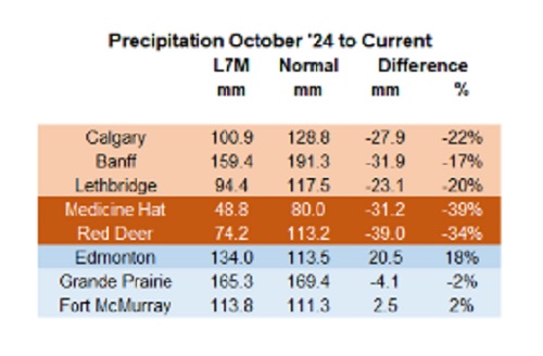

Below are my updated charts through April 2025 along with the cumulative data starting in October 2024. As you can see, central and southern Alberta are trending quite dry, while the north appears to be faring much better. However, even there, the devil is in the details. For instance, in Grande Prairie the overall precipitation level appears to be “normal”, yet in April it was bone dry and talking with someone who was recently there, they described it as a dust bowl. In short, some rainfall would be helpful. These next 3 months are fairly critical.
 |
Thanks for reading William’s Substack!
Subscribe for free to receive new posts and support my work.


Bovaer Backlash Update: Danish Farmers Get Green Light to Opt Out as UK Arla Trial Abruptly Ends!

CBC cashes in on Carney as the news industry playing field tilts further in its favour, crippling the competition

Carney’s Floor-Crossing Campaign. A Media-Staged Bid for Majority Rule That Erodes Democracy While Beijing Hovers

Canada moves forward with digital identification for federal benefits seekers
-
 MAiD2 days ago
Quebec has the highest euthanasia rate in the world at 7.4% of total deaths
-
 Frontier Centre for Public Policy20 hours ago
Richmond Mayor Warns Property Owners That The Cowichan Case Puts Their Titles At Risk
-
 Alberta1 day ago
How economic corridors could shape a stronger Canadian future
-
 Daily Caller1 day ago
Laura Ingraham’s Viral Clash With Trump Prompts Her To Tell Real Reasons China Sends Students To US
-
 Daily Caller2 days ago
Protesters Storm Elite Climate Summit In Chaotic Scene
-
 Alberta2 days ago
When Teachers Say Your Child Has Nowhere Else to Go
-
 Automotive2 days ago
The high price of green virtue
-
 Business20 hours ago
Sluggish homebuilding will have far-reaching effects on Canada’s economy