weather
A re-energized Hurricane Dorian rakes the Southeast US coast

CHARLESTON, S.C. — Re-energized at 115 mph, Hurricane Dorian raked the Southeastern U.S. coast with howling, window-rattling winds and sideways rain Thursday, knocking out power to more than 200,000 homes and businesses as it pushed northward toward North Carolina’s dangerously exposed Outer Banks.
Leaving at least 20 people dead in its wake in the devastated Bahamas, Dorian made its way up the Eastern Seaboard, sweeping past Florida on Wednesday at a relatively safe distance. From there, the Category 3 storm apparently grazed Georgia, then hugged the South Carolina coast with more serious effects.
An estimated 3 million people in Florida, Georgia and the Carolinas were warned to evacuate as the storm closed in with the potential for life-threatening storm surge. Navy ships were ordered to ride it out at sea, and military aircraft were moved inland.
At least two deaths were reported on the U.S. mainland, in Florida and North Carolina, both involving men who fell while getting ready for the storm.
The National Hurricane Center’s projected track showed Dorian passing near or over the Outer Banks on Friday, lashing the thin line of islands that stick out from the U.S. coast like a boxer’s chin. Dorian was then expected to peel away from the shoreline.
In an assault that began over Labor Day weekend, Dorian pounded the Bahamas with Category 5 winds up to 185 mph (295 kph), obliterating entire neighbourhoods and triggering a humanitarian crisis. It weakened to a Category 2 before strengthening again late Wednesday.
About 830,000 people were under mandatory evacuation orders on the South Carolina coast alone.
More than 1,500 people sought refuge in 28 shelters in South Carolina, where rain began falling late Wednesday in the historic port city of Charleston, situated on a peninsula that is prone to flooding even from ordinary storms.
As Dorian crept dangerously closer, the wind picked up, sending sheets of rain sideways. Thunder boomed in the night sky, and power flickered on and off. More than two dozen blocks were closed by flooding in the city, where stores and restaurants downtown were boarded up with wood and corrugated metal.
Dorian remained a force to be reckoned with, its swirling circle of winds and rain wrapped around a large, gaping eye visible on photos taken from space.
At 8 a.m. EDT Thursday, the hurricane was centred about 70 miles (115 kilometres) southeast of Charleston, moving north at 8 mph (13 kph) with winds of 115 mph (185 kph) extending about 60 miles (95 kilometres) outward.
Hurricane warnings were in effect for the coasts of both South and North Carolina.
Hundreds of shelter animals from coastal South Carolina arrived in Delaware ahead of the storm. The News Journal of Wilmington, Delaware, said 200 were airlifted early Tuesday from shelters in danger of flooding. About 150 more were expected to arrive via land.
Hundreds of thousands of people also were ordered off the Georgia coast. But the mayor of Tybee Island, Georgia, said Dorian inflicted little damage overnight on the small beach community. Jason Buelterman said the storm spared the 3,000 residents from flooding, with high tide about 3 feet lower than predicted.
The lone highway linking the island to Savannah on the mainland remained open throughout the night.
“If the worst that comes out of this is people blame others for calling evacuations, then that’s wonderful,” Buelterman said.
Tybee Islander Bruce Pevey went outside to take photos of unscathed homes to text to neighbours who evacuated. The storm, he said, turned out to be “a bunch of nothing.”
___
Associated Press reporters Russ Bynum in Savannah, Georgia; Gary Robertson in Raleigh, North Carolina; Jeffrey Collins in Carolina Beach, North Carolina; Jay Reeves in Birmingham, Alabama; Michael Schneider in Orlando, Florida; David Fischer in Miami; and Meg Kinnard in Charleston, South Carolina, contributed to this report.
Meg Kinnard, The Associated Press

Hurricane Melissa slammed into Jamaica on Tuesday morning as a ferocious Category 5 storm, becoming the most powerful system ever to strike the island in 174 years of recordkeeping. The eye of the hurricane made landfall near St. Elizabeth Parish on the southern coast, bringing catastrophic winds, torrential rain, and life-threatening storm surges before beginning its projected path across the island toward St. Ann Parish in the north.
The storm had already proven deadly across the Caribbean, blamed for at least seven deaths—three in Jamaica, three in Haiti, and one in the Dominican Republic—while another person remains missing. Even before landfall, landslides, uprooted trees, and widespread blackouts had been reported, with emergency officials warning that the full scope of destruction may take days to assess.
Witness the raw power of nature as a U.S. Air Force pilot navigates through the eye wall of Hurricane Melissa, a Category 5 storm with 185 mph winds sweeping across Jamaica, Haiti, and the Dominican Republic. The accompanying image captures the storm's mesmerizing eye, where life… pic.twitter.com/JtKMOyJ4ku
— SanaviNet (@Sanavi1009) October 28, 2025
According to the Associated Press, Prime Minister Andrew Holness said the government had done all it could to prepare but admitted the storm’s intensity would test Jamaica’s limits. “There is no infrastructure in the region that can withstand a Category 5,” Holness said. “The question now is the speed of recovery. That’s the challenge.”
Forecasters warned of storm surges up to 13 feet along Jamaica’s southern coast, threatening homes, hospitals, and infrastructure. Health Minister Christopher Tufton said some patients were moved to upper floors as a precaution. “We hope that will suffice for any surge that will take place,” Tufton told reporters.
🚨 BREAKING: HOSPITALS DESTROYED IN JAMAICA 🚨
Medical facilities in Black River, Jamaica have reportedly been destroyed, according to a Jamaican Senator speaking to NBC.
Amid Hurricane Melissa’s catastrophic landfall, emergency services are overwhelmed, and access to care is… pic.twitter.com/FwJsmfMvqr— Dj Steven King (@djstevenking1) October 28, 2025
Matthew Samuda, Jamaica’s Minister of Water, Environment, and Climate Change, called the situation “frightening,” noting that roughly 70 percent of the country’s population lives within three miles of the sea. Low-lying communities such as Kingston, Old Harbour Bay, Rocky Point, and St. Elizabeth were expected to bear the brunt of the flooding.
“We hope we have done enough in terms of preparation,” Samuda said in an interview with the BBC, urging residents to seek shelter and pleading with Jamaicans abroad to call loved ones “before it’s too late.” Still, officials acknowledged that many have refused to leave their homes, choosing to guard their property instead.
As Melissa churns across the island, authorities warn that the coming hours will be critical. The storm’s powerful winds and deluge threaten to cut off entire communities, with the recovery effort expected to be long and grueling once skies finally clear.
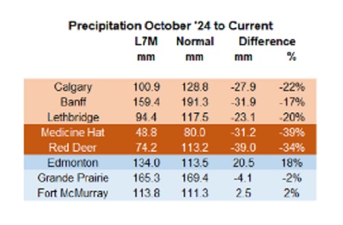

Below are my updated charts through April 2025 along with the cumulative data starting in October 2024. As you can see, central and southern Alberta are trending quite dry, while the north appears to be faring much better. However, even there, the devil is in the details. For instance, in Grande Prairie the overall precipitation level appears to be “normal”, yet in April it was bone dry and talking with someone who was recently there, they described it as a dust bowl. In short, some rainfall would be helpful. These next 3 months are fairly critical.
 |
Thanks for reading William’s Substack!
Subscribe for free to receive new posts and support my work.


Canada moves forward with digital identification for federal benefits seekers

Chinese-Owned Trailer Park Beside U.S. Stealth Bomber Base Linked to Alleged Vancouver Repression Case

School defunding petition in Alberta is a warning to parents

Liberals refuse to disclose the amount of taxpayer dollars headed to LGBT projects in foreign countries
-
 Energy14 hours ago
It should not take a crisis for Canada to develop the resources that make people and communities thrive.
-
 Fraser Institute1 day ago
Courts and governments caused B.C.’s property crisis—they’re not about to fix it
-
 Alberta1 day ago
ChatGPT may explain why gap between report card grades and standardized test scores is getting bigger
-
 Alberta22 hours ago
Federal budget: It’s not easy being green
-
 Censorship Industrial Complex2 days ago
EU’s “Democracy Shield” Centralizes Control Over Online Speech
-
 International2 days ago
US announces Operation Southern Spear, targeting narco-terrorists
-
 Education1 day ago
Johns Hopkins University Announces Free Tuition For Most Students
-
 International2 days ago
State Department designates European Antifa groups foreign terror organizations