weather
A re-energized Hurricane Dorian rakes the Southeast US coast

CHARLESTON, S.C. — Re-energized at 115 mph, Hurricane Dorian raked the Southeastern U.S. coast with howling, window-rattling winds and sideways rain Thursday, knocking out power to more than 200,000 homes and businesses as it pushed northward toward North Carolina’s dangerously exposed Outer Banks.
Leaving at least 20 people dead in its wake in the devastated Bahamas, Dorian made its way up the Eastern Seaboard, sweeping past Florida on Wednesday at a relatively safe distance. From there, the Category 3 storm apparently grazed Georgia, then hugged the South Carolina coast with more serious effects.
An estimated 3 million people in Florida, Georgia and the Carolinas were warned to evacuate as the storm closed in with the potential for life-threatening storm surge. Navy ships were ordered to ride it out at sea, and military aircraft were moved inland.
At least two deaths were reported on the U.S. mainland, in Florida and North Carolina, both involving men who fell while getting ready for the storm.
The National Hurricane Center’s projected track showed Dorian passing near or over the Outer Banks on Friday, lashing the thin line of islands that stick out from the U.S. coast like a boxer’s chin. Dorian was then expected to peel away from the shoreline.
In an assault that began over Labor Day weekend, Dorian pounded the Bahamas with Category 5 winds up to 185 mph (295 kph), obliterating entire neighbourhoods and triggering a humanitarian crisis. It weakened to a Category 2 before strengthening again late Wednesday.
About 830,000 people were under mandatory evacuation orders on the South Carolina coast alone.
More than 1,500 people sought refuge in 28 shelters in South Carolina, where rain began falling late Wednesday in the historic port city of Charleston, situated on a peninsula that is prone to flooding even from ordinary storms.
As Dorian crept dangerously closer, the wind picked up, sending sheets of rain sideways. Thunder boomed in the night sky, and power flickered on and off. More than two dozen blocks were closed by flooding in the city, where stores and restaurants downtown were boarded up with wood and corrugated metal.
Dorian remained a force to be reckoned with, its swirling circle of winds and rain wrapped around a large, gaping eye visible on photos taken from space.

At 8 a.m. EDT Thursday, the hurricane was centred about 70 miles (115 kilometres) southeast of Charleston, moving north at 8 mph (13 kph) with winds of 115 mph (185 kph) extending about 60 miles (95 kilometres) outward.
Hurricane warnings were in effect for the coasts of both South and North Carolina.
Hundreds of shelter animals from coastal South Carolina arrived in Delaware ahead of the storm. The News Journal of Wilmington, Delaware, said 200 were airlifted early Tuesday from shelters in danger of flooding. About 150 more were expected to arrive via land.
Hundreds of thousands of people also were ordered off the Georgia coast. But the mayor of Tybee Island, Georgia, said Dorian inflicted little damage overnight on the small beach community. Jason Buelterman said the storm spared the 3,000 residents from flooding, with high tide about 3 feet lower than predicted.
The lone highway linking the island to Savannah on the mainland remained open throughout the night.
“If the worst that comes out of this is people blame others for calling evacuations, then that’s wonderful,” Buelterman said.
Tybee Islander Bruce Pevey went outside to take photos of unscathed homes to text to neighbours who evacuated. The storm, he said, turned out to be “a bunch of nothing.”
___
Associated Press reporters Russ Bynum in Savannah, Georgia; Gary Robertson in Raleigh, North Carolina; Jeffrey Collins in Carolina Beach, North Carolina; Jay Reeves in Birmingham, Alabama; Michael Schneider in Orlando, Florida; David Fischer in Miami; and Meg Kinnard in Charleston, South Carolina, contributed to this report.
Meg Kinnard, The Associated Press

Agricultural Moisture Situation Update – January 3, 2024
Synopsis
This year’s El Niño has developed into a strong El Niño and currently has a 54% chance of developing into a “historically strong” event, according to NOAA. Current forecasts are projecting El Niño to diminish in April 2024. In the past for Alberta, not all El Niño’s have resulted in warmer and drier weather; however, this unusually warm and dry winter will forever be tied to the 2023-2024 El Niño and will serve as an important data point in the future.
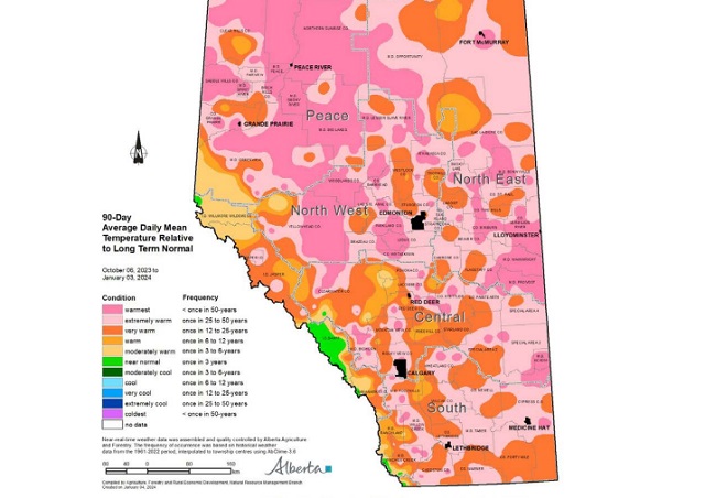
In the 90-days since October 6, 2023, temperatures have remained well above average, with many parts of the northern-half of the province seeing temperatures this warm less than once in 50 years (Map 1). This coupled with low precipitation accumulations has resulted in virtually snow free
conditions across parts of all four of our agricultural regions
(Map 2).
Winter Precipitation Accumulations
November 1, 2023 to January 3, 2024
Since November 1st, the unofficial start to winter in Alberta, precipitation has been well below average across much of Alberta’s agricultural areas (Map 3).

Most of the lands south of Grande Prairie and north of Ponoka are estimated to have a winter thus far, this dry on average, less than once in 50-years. Dry conditions have also persisted across the Central and Southern Regions, ranging from a few widely scattered pockets of near normal to at least once in 25 year lows, centered around the Jenner area (approx. 200 km east of Calgary). Total accumulations currently range from less than 3 mm through parts of the North West and North East Regions up to only 20-30 mm along the foothills and through the western and northern portions of the Peace Region (Map 4).


For the dryer parts of the North West and North East Regions this translates to less than 10% of the 1991-2020 average (Map 5).

Elsewhere, most other lands have received precipitation accumulations that have generally been less
than 50% of the 1991-2020 average.
Perspective
From an annual moisture budget perspective, October through to March generally mark the dry season across the agricultural areas (Map 6), accounting for only about 20% of average annual accumulations across most of the Southern Region, to upwards of 30-35% across the Peace Region.

These significant moisture deficits thus far (50% of the way through the dry season), while discouraging to many, make up only a small portion of the annual moisture budget for an area. Winter is not over yet and if the current forecast is correct, a significant cold snap is on its way over the next few days and it is expected to persist well into next week, perhaps even longer. Along with the cold snap, there is also a forecast for moisture and the promise of at least some snow cover across many areas.
Spring is yet many weeks away and anything can happen between now and then. Furthermore, February on average, is the driest month of the year with most agricultural lands normally receiving less than 15 mm of moisture during this month (Map 6). Let’s hope, for the sake of our producers,
that we descend into at least near “normal” winter conditions and that we see one of Alberta’s famous weather reversals, with respect to moisture. Above average snow fall is very much needed now. Much of the land is extremely dry and has been held tenaciously in the grip of a long-lasting dry
cycle that needs to end soon!

Monday, August 1st will be a day hundreds of Albertans will never forget. The hail storm that devastated an area of Central Alberta resulted in a series of terrifying experiences for motorists on the QE II, especially around Antler Hill, just north of Innisfail. This is a map of the area most affected by the largest hail stones most have seen in their lifetimes.

Yes we’ve all heard people talk about “baseball” or “tennis ball” sized hail in the past. In this case, those comparisons are simply too small!


Now you can imagine how terrifying it must have been to be caught driving on the QE II south of Red Deer and north of Innisfail during this storm on Monday, August 1st. Here’s what that felt like, courtesy of Gibran Marquez as posted on the Facebook Page Alberta Storm Reports
This couple was remarkably calm considering the battering they were experiencing!
The immediate aftermath.


Pfizer Lied to Us Again

Japanese study finds ‘significant increases’ in cancer deaths after third mRNA COVID doses

Scotland’s crazy anti-hate law may be sign of things to come here

Did Lockdowns Set a Global Revolt in Motion?

-
 Censorship Industrial Complex2 days ago
Desperate Liberals move to stop MPs from calling Trudeau ‘corrupt’
-
 Business1 day ago
Federal government’s ‘fudget budget’ relies on fanciful assumptions of productivity growth
-
 Health1 day ago
Transgender activists are threatening the author of scathing UK report on child ‘sex changes’
-
 conflict2 days ago
Col. Douglas Macgregor: US is ‘facing disaster’ as it funds overseas wars while bankrupt
-
 conflict21 hours ago
Col. Douglas Macgregor torches Trump over support for bill funding wars in Ukraine and Israel
-
 Great Reset2 days ago
Terrorists Welcome: Chronic counterterrorism lapses at the border demand investigation
-
 Energy2 days ago
A Wealth-Creating Way of Reducing Global CO2 Emissions
-
 COVID-191 day ago
Inquiry shows Canadian gov’t agencies have spent $10 million on social media ads for COVID jabs