weather
France fries: Record heat hits tourists, schools, hospitals

PARIS — Schools are dousing kids with water and nursing homes are equipping the elderly with hydration sensors as France and other nations battle a record-setting heat wave baking much of Europe.
Several people have died around the continent in incidents that authorities are linking to the exceptional weather. A major wildfire raged Friday in Spain, sparked when a pile of chicken dung spontaneously combusted in the heat.
Several countries have reported record temperatures this week, and France hit its all-time heat record Friday: 44.3 degrees Celsius (111 F) in the southern town of Carpentras, according to French media.
The French national weather service activated its highest-level heat danger alert for the first time, putting four regions around Marseille and Montpellier in the south of the country under special watch Friday.
Those schools that stayed open worked to keep kids cool. Teachers at the Victor Hugo Primary School in Colombes near Paris abandoned suffocating classrooms and are keeping children outside all day, spraying them with water and organizing quiet activities in the shade.
“I make them go in the playground with books, in the shade, they must stay seated,” said teacher Valerie Prevost. “We tell them to dampen their caps, to drink regularly.”
About 4,000 schools closed because they couldn’t ensure safe conditions, and local authorities
Some criticized the government for going overboard, but Prime Minister Edouard Philippe defended the efforts after 15,000 people died in a heat wave in 2003 that woke France up to the risks.
“This heat wave is exceptional by its intensity and its earliness,” he told reporters.
“Measures have been taken for the most vulnerable people,” he said “But given the intensity of the heat wave, it’s the entire population who must be careful today … both for oneself and for loved ones and
Italy put 16 cities under alerts for high temperatures, and civil security services distributed water to tourists visiting famed sites around Rome under a scorching sun.
Heat was blamed for the deaths of two people in Spain, private news agency Europa Press reported Friday.
An 80-year-old man collapsed and died in the street in Valladolid, in northwest Spain, the agency said, and a 17-year-old boy died in the southern city of Cordoba after diving into a swimming pool and losing consciousness.
Four people have drowned so far in France this week, and a 12-year-old girl drowned in a river near Manchester, England. France’s health minister and British police warned people to swim only in authorized areas.
France has also seen an uptick in so-called street-pooling, or illegally opening fire hydrants. A 6-year-old child is in life-threatening condition after being hit by water shooting from a cracked-open fire hydrant in the Paris suburb of Saint-Denis, broadcaster France-Info reported.
More than 600 firefighters and six water-dropping aircraft were battling the worst fire in two decades in the Catalonia region Friday, as Spain is forecast to endure the peak of its heat wave, with temperatures expected to exceed 40 degrees Celsius (104 Fahrenheit).
In Berlin, a police unit turned water cannons — usually used against rioters — on city trees, to cool them down.
___
Barry Hatton in Lisbon, Danica Kirka in London and Catherine Gaschka in Colombes, France, contributed.
Angela Charlton, The Associated Press
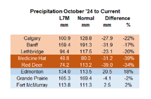

Below are my updated charts through April 2025 along with the cumulative data starting in October 2024. As you can see, central and southern Alberta are trending quite dry, while the north appears to be faring much better. However, even there, the devil is in the details. For instance, in Grande Prairie the overall precipitation level appears to be “normal”, yet in April it was bone dry and talking with someone who was recently there, they described it as a dust bowl. In short, some rainfall would be helpful. These next 3 months are fairly critical.
 |
Thanks for reading William’s Substack!
Subscribe for free to receive new posts and support my work.
From the Daily Caller News Foundation
![]()
By Hailey Gomez
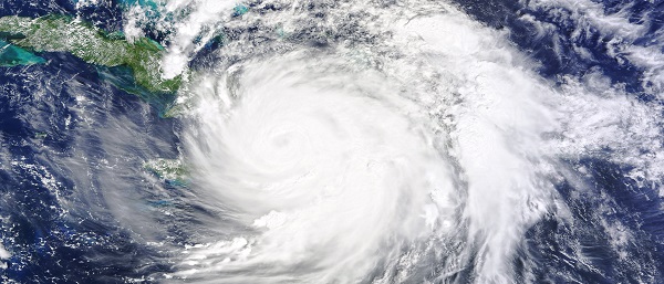
Hurricane Milton officially made landfall near Siesta Key, Florida, on Wednesday night as local residents have either bunkered down or fled from the areas expected to be hit, according to the National Hurricane Center.
Dropping from a Category 4 to Category 3 storm right before landfall, the devastating storm had 120 mph sustained winds and higher gusts, the National Hurricane Center reported. Warnings about Hurricane Milton began early in the week, with lawmakers and officials urging residents within Florida’s Gulf Coast area to flee from their homes or be prepared for disastrous impacts, according to The Associated Press News.
“As Hurricane Milton makes landfall near Sarasota county, now is the time to shelter in place. First responders are staged and ready to go, as soon as weather conditions allow. Search and rescue efforts will be well underway to save lives before dawn, and they will continue for as long as it takes,” Republican Florida Gov. Ron DeSantis posted to X.
An estimated 2 million people, including those within the Tampa, St. Petersburg and Clearwater, Florida, area, were under a flash-flood warning from the Tampa National Weather Service, as “between 6 and 12 inches of rain” had already fallen.
Violent videos of the storm have began to circulating on X showing powerful winds tearing apart homes, trees and power lines.
BREAKING: Multiple people dead following tornado outbreak from Hurricane Milton in St. Lucie County, Florida, local media reports#HurricanMilton #miltonhurricane #Milton #StormFootage #FloridaStorm https://t.co/EoMxODqfuV pic.twitter.com/UrMEsXE22j
— Smriti Sharma (@SmritiSharma_) October 10, 2024
Early reports indicated fatalities occurred due to tornado touchdowns prior to landfall on Florida’s Atlantic coast, according to West Palm Beach-based affiliate WPTV. While details remain unclear about the deceased, St. Lucie County Sheriff Keith Pearson confirmed to the outlet “multiple people” have been killed.
The storm comes on the heels of Hurricane Helene, a Category 4 storm, which resulted in the deaths of over 200 people as it ripped through North Carolina, Georgia, South Carolina, Tennessee and Virginia after first making landfall in Florida on the evening of Sept. 26.

Court compels RCMP and TD Bank to hand over records related to freezing of peaceful protestor’s bank accounts
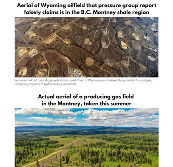
B.C. Residents File Competition Bureau Complaint Against David Suzuki Foundation for Use of False Imagery in Anti-Energy Campaigns

Alberta uncorks new rules for liquor and cannabis

Trump transportation secretary tells governors to remove ‘rainbow crosswalks’
-
 Alberta10 hours ago
COWBOY UP! Pierre Poilievre Promises to Fight for Oil and Gas, a Stronger Military and the Interests of Western Canada
-
 Alberta1 day ago
Alberta Next: Immigration
-
 Business2 days ago
The Digital Services Tax Q&A: “It was going to be complicated and messy”
-
 International2 days ago
Elon Musk forms America Party after split with Trump
-
 Alberta10 hours ago
Alberta and Ontario sign agreements to drive oil and gas pipelines, energy corridors, and repeal investment blocking federal policies
-
 COVID-1914 hours ago
FDA requires new warning on mRNA COVID shots due to heart damage in young men
-
 Alberta Sports Hall of Fame and Museum1 day ago
Alberta Sports Hall of Fame 2025 Inductee Profiles – Para Nordic Skiing – Brian and Robin McKeever
-
 Crime11 hours ago
Eyebrows Raise as Karoline Leavitt Answers Tough Questions About Epstein