weather
storm
June 8, 2017 @ 8:40pm north of #Lethbridge. #abstorm #yql pic.twitter.com/jKU2TUHwNS
— James Kindt (@james_kindt) June 9, 2017
Agricultural Moisture Situation Update – January 3, 2024
Synopsis
This year’s El Niño has developed into a strong El Niño and currently has a 54% chance of developing into a “historically strong” event, according to NOAA. Current forecasts are projecting El Niño to diminish in April 2024. In the past for Alberta, not all El Niño’s have resulted in warmer and drier weather; however, this unusually warm and dry winter will forever be tied to the 2023-2024 El Niño and will serve as an important data point in the future.
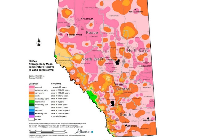
In the 90-days since October 6, 2023, temperatures have remained well above average, with many parts of the northern-half of the province seeing temperatures this warm less than once in 50 years (Map 1). This coupled with low precipitation accumulations has resulted in virtually snow free
conditions across parts of all four of our agricultural regions
(Map 2).
Winter Precipitation Accumulations
November 1, 2023 to January 3, 2024
Since November 1st, the unofficial start to winter in Alberta, precipitation has been well below average across much of Alberta’s agricultural areas (Map 3).

Most of the lands south of Grande Prairie and north of Ponoka are estimated to have a winter thus far, this dry on average, less than once in 50-years. Dry conditions have also persisted across the Central and Southern Regions, ranging from a few widely scattered pockets of near normal to at least once in 25 year lows, centered around the Jenner area (approx. 200 km east of Calgary). Total accumulations currently range from less than 3 mm through parts of the North West and North East Regions up to only 20-30 mm along the foothills and through the western and northern portions of the Peace Region (Map 4).

For the dryer parts of the North West and North East Regions this translates to less than 10% of the 1991-2020 average (Map 5).

Elsewhere, most other lands have received precipitation accumulations that have generally been less
than 50% of the 1991-2020 average.
Perspective
From an annual moisture budget perspective, October through to March generally mark the dry season across the agricultural areas (Map 6), accounting for only about 20% of average annual accumulations across most of the Southern Region, to upwards of 30-35% across the Peace Region.

These significant moisture deficits thus far (50% of the way through the dry season), while discouraging to many, make up only a small portion of the annual moisture budget for an area. Winter is not over yet and if the current forecast is correct, a significant cold snap is on its way over the next few days and it is expected to persist well into next week, perhaps even longer. Along with the cold snap, there is also a forecast for moisture and the promise of at least some snow cover across many areas.
Spring is yet many weeks away and anything can happen between now and then. Furthermore, February on average, is the driest month of the year with most agricultural lands normally receiving less than 15 mm of moisture during this month (Map 6). Let’s hope, for the sake of our producers,
that we descend into at least near “normal” winter conditions and that we see one of Alberta’s famous weather reversals, with respect to moisture. Above average snow fall is very much needed now. Much of the land is extremely dry and has been held tenaciously in the grip of a long-lasting dry
cycle that needs to end soon!
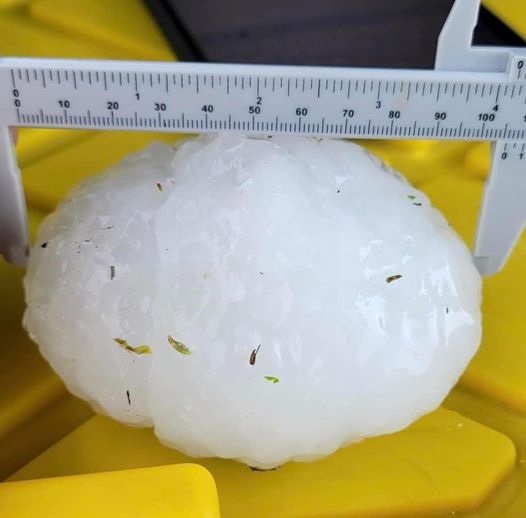
Monday, August 1st will be a day hundreds of Albertans will never forget. The hail storm that devastated an area of Central Alberta resulted in a series of terrifying experiences for motorists on the QE II, especially around Antler Hill, just north of Innisfail. This is a map of the area most affected by the largest hail stones most have seen in their lifetimes.

Yes we’ve all heard people talk about “baseball” or “tennis ball” sized hail in the past. In this case, those comparisons are simply too small!


Now you can imagine how terrifying it must have been to be caught driving on the QE II south of Red Deer and north of Innisfail during this storm on Monday, August 1st. Here’s what that felt like, courtesy of Gibran Marquez as posted on the Facebook Page Alberta Storm Reports
This couple was remarkably calm considering the battering they were experiencing!
The immediate aftermath.


New Report Details Horrifying Cost of Fauci’s Failures

Justices’ Grave Error in Murthy v. Missouri

It’s time for an honest conversation about the costs of new federal programs

Caitlin & Zach: Now Comes The Complicated Part
-
 Housing2 days ago
Trudeau admits immigration too much for Canada to ‘absorb’ but keeps target at record high
-
 Censorship Industrial Complex2 days ago
Trudeau’s new online censorship law – Problems with Bill C-63 / the Online Arms Law
-
 conflict2 days ago
Western leadership’s detachment from reality is causing terror and death across the globe
-
 Business2 days ago
Decarbonization deal opens new chapter in Alberta-Japan relationship
-
 Censorship Industrial Complex2 days ago
NPR senior editor admits extreme bias in Russia collusion, Hunter Biden laptop, COVID coverage
-
 2024 City Councilor By-Election2 days ago
Get to know your candidates for city council: Calvin Yzerman
-
 National2 days ago
Trudeau drops nearly $200K on airplane food during six-day trip
-
 2024 City Councilor By-Election2 days ago
Get to know your candidates for city council: Liam (The Level) Milaney