weather
Tornadoes leave trail of destruction across Ohio, Indiana

BROOKVILLE, Ohio — A rapid-fire line of apparent tornadoes tore across Indiana and Ohio overnight, packed so closely together that one crossed the path carved by another.
There were no immediate reports of any deaths or serious injuries in the twisters, among 52 tornadoes that may have touched down Monday across eight states as waves of severe weather swept across the nation’s mid-section.
A tally of storm reports posted online by the National Oceanic and Atmospheric Administration’s Storm Prediction Center shows that 14 suspected tornadoes touched down in Indiana, 10 in Colorado and nine in Ohio. Six suspected tornadoes were reported in Iowa, five in Nebraska, four in Illinois, three in Minnesota, while one suspected tornado was reported in Idaho in the West.
At least half a dozen communities from eastern Indiana through central Ohio suffered damage, according to the National Weather Service. The storms damaged homes, blew out windows, toppled trees and left debris so thick that at one point, highway crews had to use snowplows to clear an interstate.
In Indiana, at least 75 homes were damaged in Pendleton and the nearby community of Huntsville, said Madison County Emergency Management spokesman Todd Harmeson. No serious injuries were reported in the area or other parts of the state.
Madison County authorities said roads in Pendleton, about 35 miles (56
The National Weather Service said a survey team will investigate damage in Madison County and possibly in Henry County. Another team may survey damage in Tippecanoe County.
Some of the heaviest hits were recorded in towns just outside Dayton, Ohio, where officials were still assessing damage.
In Vandalia, about 10 miles (16
“I just got down on all fours and covered my head with my hands,” said Dutmers, who said the winds blew out windows around his house, filled rooms with storm debris, and took down most of his trees. But he and his wife were not injured and the house is still livable, he said.
The National Weather Service tweeted Monday night that a “large and dangerous tornado” hit near Trotwood, Ohio, eight miles (12
Just before midnight, not 40 minutes after that tornado cut through, the weather service tweeted that another one was traversing its path, churning up debris densely enough to be seen on radar.
The aftermath left some lanes of Interstate 75 blocked north of Dayton. Trucks with plows were scraping tree branches and rubble to the side to get the major north-south route reopened, according to Matt Bruning, a spokesman for the Ohio Department of Transportation.
Trying to clear the debris in the middle of the night is a difficult task, complicated by darkness and downed power lines, Bruning said.

“We’ll do a more thorough cleaning after we get lanes opened,” he told The Associated Press by text early Tuesday, noting that tow trucks would have to haul off damaged vehicles along the roadway, too.
In Brookville, west of Dayton, the storm tore roofs off schools, destroyed a barn and heavily damaged houses.
Crews were also clearing debris in two other counties northwest of Dayton.
In Dayton, the storm caused a few minor injuries but no reported fatalities. Dayton Fire Chief Jeffrey Payne called that “pretty miraculous” during a Tuesday morning briefing. Payne attributed the good news to people heeding early warnings about the storm.
Residents say sirens started going off around 10:30 p.m. Monday ahead of the storm.
Mayor Nan Whaley urged residents to check on
City Manager Shelley Dickstein said a boil advisory has been issued for residents after the storms cut power to Dayton’s pump stations, and that generators are being rushed in.
The response will require a “multi-day restoration effort,” utility Dayton Power & Light said in an early morning tweet. The company said 64,000 of its customers alone were without power.
In Montgomery County, which includes Dayton, Sheriff Rob Streck said many roads were impassable. The Montgomery County sheriff’s office initially said the Northridge High School gymnasium would serve as an emergency shelter in Dayton but later said it wasn’t useable.
The latest apparent tornadoes came two nights after a twister struck a motel and mobile home park in El Reno, Oklahoma, killing two people and injuring 29. President Donald Trump tweeted Tuesday morning that that he spoke from Japan with Oklahoma Gov. Kevin Stitt and told him that the Federal Emergency Management Agency and the “federal government are fully behind him and the great people of Oklahoma.”
___
Associated Press writer David Runk contributed to this report from Detroit. Franko reported from Columbus, Ohio.
Angie Wang, John Minchillo And Kantele Franko, The Associated Press

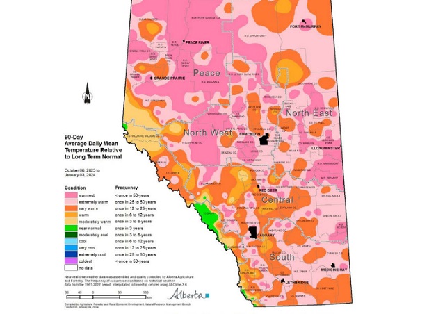
Agricultural Moisture Situation Update – January 3, 2024
Synopsis
This year’s El Niño has developed into a strong El Niño and currently has a 54% chance of developing into a “historically strong” event, according to NOAA. Current forecasts are projecting El Niño to diminish in April 2024. In the past for Alberta, not all El Niño’s have resulted in warmer and drier weather; however, this unusually warm and dry winter will forever be tied to the 2023-2024 El Niño and will serve as an important data point in the future.
In the 90-days since October 6, 2023, temperatures have remained well above average, with many parts of the northern-half of the province seeing temperatures this warm less than once in 50 years (Map 1). This coupled with low precipitation accumulations has resulted in virtually snow free
conditions across parts of all four of our agricultural regions
(Map 2).
Winter Precipitation Accumulations
November 1, 2023 to January 3, 2024
Since November 1st, the unofficial start to winter in Alberta, precipitation has been well below average across much of Alberta’s agricultural areas (Map 3).

Most of the lands south of Grande Prairie and north of Ponoka are estimated to have a winter thus far, this dry on average, less than once in 50-years. Dry conditions have also persisted across the Central and Southern Regions, ranging from a few widely scattered pockets of near normal to at least once in 25 year lows, centered around the Jenner area (approx. 200 km east of Calgary). Total accumulations currently range from less than 3 mm through parts of the North West and North East Regions up to only 20-30 mm along the foothills and through the western and northern portions of the Peace Region (Map 4).


For the dryer parts of the North West and North East Regions this translates to less than 10% of the 1991-2020 average (Map 5).

Elsewhere, most other lands have received precipitation accumulations that have generally been less
than 50% of the 1991-2020 average.
Perspective
From an annual moisture budget perspective, October through to March generally mark the dry season across the agricultural areas (Map 6), accounting for only about 20% of average annual accumulations across most of the Southern Region, to upwards of 30-35% across the Peace Region.

These significant moisture deficits thus far (50% of the way through the dry season), while discouraging to many, make up only a small portion of the annual moisture budget for an area. Winter is not over yet and if the current forecast is correct, a significant cold snap is on its way over the next few days and it is expected to persist well into next week, perhaps even longer. Along with the cold snap, there is also a forecast for moisture and the promise of at least some snow cover across many areas.
Spring is yet many weeks away and anything can happen between now and then. Furthermore, February on average, is the driest month of the year with most agricultural lands normally receiving less than 15 mm of moisture during this month (Map 6). Let’s hope, for the sake of our producers,
that we descend into at least near “normal” winter conditions and that we see one of Alberta’s famous weather reversals, with respect to moisture. Above average snow fall is very much needed now. Much of the land is extremely dry and has been held tenaciously in the grip of a long-lasting dry
cycle that needs to end soon!
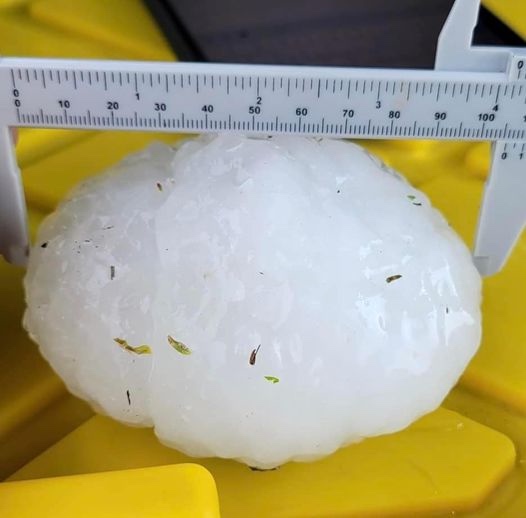
Monday, August 1st will be a day hundreds of Albertans will never forget. The hail storm that devastated an area of Central Alberta resulted in a series of terrifying experiences for motorists on the QE II, especially around Antler Hill, just north of Innisfail. This is a map of the area most affected by the largest hail stones most have seen in their lifetimes.

Yes we’ve all heard people talk about “baseball” or “tennis ball” sized hail in the past. In this case, those comparisons are simply too small!


Now you can imagine how terrifying it must have been to be caught driving on the QE II south of Red Deer and north of Innisfail during this storm on Monday, August 1st. Here’s what that felt like, courtesy of Gibran Marquez as posted on the Facebook Page Alberta Storm Reports
This couple was remarkably calm considering the battering they were experiencing!
The immediate aftermath.


Pfizer Lied to Us Again

Japanese study finds ‘significant increases’ in cancer deaths after third mRNA COVID doses

Scotland’s crazy anti-hate law may be sign of things to come here

Did Lockdowns Set a Global Revolt in Motion?

-
 Censorship Industrial Complex2 days ago
Desperate Liberals move to stop MPs from calling Trudeau ‘corrupt’
-
 Business1 day ago
Federal government’s ‘fudget budget’ relies on fanciful assumptions of productivity growth
-
 Health1 day ago
Transgender activists are threatening the author of scathing UK report on child ‘sex changes’
-
 conflict2 days ago
Col. Douglas Macgregor: US is ‘facing disaster’ as it funds overseas wars while bankrupt
-
 conflict24 hours ago
Col. Douglas Macgregor torches Trump over support for bill funding wars in Ukraine and Israel
-
 Energy2 days ago
A Wealth-Creating Way of Reducing Global CO2 Emissions
-
 COVID-191 day ago
Inquiry shows Canadian gov’t agencies have spent $10 million on social media ads for COVID jabs
-
 Alberta19 hours ago
Red Deer Doctor critical of Alberta’s COVID response to submit report to Danielle Smith this May