weather
Rescuers struggle to reach storm-hit area in Nepal; 28 dead

BHARWALIA, Nepal — Villagers who survived a powerful rainstorm that killed at least 28 people and injured hundreds in southern Nepal searched for food and shelter Monday as rescuers struggled to reach remote areas.
High winds during the storm Sunday night flipped cars and blew a bus carrying at least 40 people off a highway, killing some.
Police said most of the deaths were caused by collapsing walls and falling bricks in homes and toppled trees and electrical poles.
The storm swept through villages in a farming region in Bara and Parsa districts. The government administrator in Bara, Rajesh Poudel, said 27 were killed there. One person died in
The area is about 120
Police officers and soldiers were helping people injured by the rainstorm. Villagers from
Prime Minister Khadga Prasad Oli
The National Emergency Operation Center in Kathmandu said 612 people were injured and teams with tents and other material were sent to the area.

Villagers salvaged what they could from what was left of their homes in Bharwalia village, where most people live in huts made of mud and bricks with straw and stone roofs.
Most of the huts were blown down by the strong winds, leaving people without shelter or food.
“The storm took everything we had, including all the goods we had. We have no food to eat or any roof over our heads,” said Jebeda Khatung, who was digging through the debris in hopes of finding some of her belongings. All four members of her family survived.
“It began with a hailstorm and rain and the wind picked up. The roof was shaking and when I went to check if the roof was damaged, the door was blown open and I was thrown on the ground and hit my head,” said Mamata Devi Patel, whose head was wrapped in a bandage.
Local television showed the injured being taken to a hospital in cars, ambulances and even on motorcycles, but roads in many villages were blocked by fallen trees and electricity poles.
Pre-monsoon storms with strong winds and rain are common in March and April.
The provincial government announced 300,000 rupees ($2,725) in financial assistance for families of each of the dead.
Upendra Man Singh, The Associated Press

Agricultural Moisture Situation Update – January 3, 2024
Synopsis
This year’s El Niño has developed into a strong El Niño and currently has a 54% chance of developing into a “historically strong” event, according to NOAA. Current forecasts are projecting El Niño to diminish in April 2024. In the past for Alberta, not all El Niño’s have resulted in warmer and drier weather; however, this unusually warm and dry winter will forever be tied to the 2023-2024 El Niño and will serve as an important data point in the future.
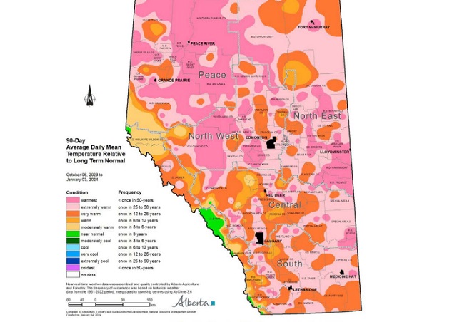
In the 90-days since October 6, 2023, temperatures have remained well above average, with many parts of the northern-half of the province seeing temperatures this warm less than once in 50 years (Map 1). This coupled with low precipitation accumulations has resulted in virtually snow free
conditions across parts of all four of our agricultural regions
(Map 2).
Winter Precipitation Accumulations
November 1, 2023 to January 3, 2024
Since November 1st, the unofficial start to winter in Alberta, precipitation has been well below average across much of Alberta’s agricultural areas (Map 3).

Most of the lands south of Grande Prairie and north of Ponoka are estimated to have a winter thus far, this dry on average, less than once in 50-years. Dry conditions have also persisted across the Central and Southern Regions, ranging from a few widely scattered pockets of near normal to at least once in 25 year lows, centered around the Jenner area (approx. 200 km east of Calgary). Total accumulations currently range from less than 3 mm through parts of the North West and North East Regions up to only 20-30 mm along the foothills and through the western and northern portions of the Peace Region (Map 4).

For the dryer parts of the North West and North East Regions this translates to less than 10% of the 1991-2020 average (Map 5).

Elsewhere, most other lands have received precipitation accumulations that have generally been less
than 50% of the 1991-2020 average.
Perspective
From an annual moisture budget perspective, October through to March generally mark the dry season across the agricultural areas (Map 6), accounting for only about 20% of average annual accumulations across most of the Southern Region, to upwards of 30-35% across the Peace Region.

These significant moisture deficits thus far (50% of the way through the dry season), while discouraging to many, make up only a small portion of the annual moisture budget for an area. Winter is not over yet and if the current forecast is correct, a significant cold snap is on its way over the next few days and it is expected to persist well into next week, perhaps even longer. Along with the cold snap, there is also a forecast for moisture and the promise of at least some snow cover across many areas.
Spring is yet many weeks away and anything can happen between now and then. Furthermore, February on average, is the driest month of the year with most agricultural lands normally receiving less than 15 mm of moisture during this month (Map 6). Let’s hope, for the sake of our producers,
that we descend into at least near “normal” winter conditions and that we see one of Alberta’s famous weather reversals, with respect to moisture. Above average snow fall is very much needed now. Much of the land is extremely dry and has been held tenaciously in the grip of a long-lasting dry
cycle that needs to end soon!
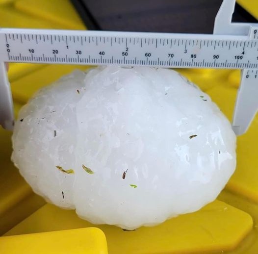
Monday, August 1st will be a day hundreds of Albertans will never forget. The hail storm that devastated an area of Central Alberta resulted in a series of terrifying experiences for motorists on the QE II, especially around Antler Hill, just north of Innisfail. This is a map of the area most affected by the largest hail stones most have seen in their lifetimes.

Yes we’ve all heard people talk about “baseball” or “tennis ball” sized hail in the past. In this case, those comparisons are simply too small!


Now you can imagine how terrifying it must have been to be caught driving on the QE II south of Red Deer and north of Innisfail during this storm on Monday, August 1st. Here’s what that felt like, courtesy of Gibran Marquez as posted on the Facebook Page Alberta Storm Reports

This couple was remarkably calm considering the battering they were experiencing!
The immediate aftermath.


Pfizer Lied to Us Again

Japanese study finds ‘significant increases’ in cancer deaths after third mRNA COVID doses

Canada’s intelligence chief says he personally warned Trudeau about China’s election meddling

Scotland’s crazy anti-hate law may be sign of things to come here
-
 Business2 days ago
Maxime Bernier warns Canadians of Trudeau’s plan to implement WEF global tax regime
-
 International1 day ago
UN attacks stay-at-home motherhood as ‘gender inequality’
-
 Censorship Industrial Complex8 hours ago
Desperate Liberals move to stop MPs from calling Trudeau ‘corrupt’
-
 COVID-191 day ago
WHO Official Admits the Truth About Passports
-
 Alberta1 day ago
Province to stop municipalities overcharging on utility bills
-
 Energy1 day ago
Anti-LNG activists have decided that they now actually care for LNG investors after years of calling to divest
-
 Alberta15 hours ago
Alberta government should create flat 8% personal and business income tax rate in Alberta
-
 Housing16 hours ago
Trudeau’s 2024 budget could drive out investment as housing bubble continues